Thursday, December 30, 2010

Live with Stress and Reality


Have you ever read any people's blogs about their recent lives, especially the one that you used to hate before? I accidentally found out a person's blog, which I am interested in reading it right now. The person and I had some misunderstandings and arguments with each other when we were young. We used to be friends. However, we became two strangers after the argument because both of us said something hurtful to each other. After 10 years, both of us have grown up a lot and turn to be more mature. When I see her blog, I realize her emotions and impression towards human life and love. Ironically, we didn't even talk about our life goals and philosophy when we were still friends.

Her blog shows her confusion towards her goal and love. I experience similar identity confusion as hers, but hers is stronger than mine. I found out that she has a high expectation about her love, and an unsure plan of life. Each of her blog entry implies sadness and loneliness. Due to the fact that we do not keep in touch and that we are in different part of the world where are far from each other, I feel weird to cheer her up and leave her a comment in the blog after all these years. Therefore, I leave my words here for myself as well as for all the friends I love (hope you are reading my blog=)).

1. Everyone has his or her own stress. We cannot remove stress but we can live with it. Treat it as our motivation, our partner, and our supervisor.

2. Dreams are very important. Don't blame yourself if you cannot achieve the targets you used to have. Because you are in the right direction already, you just need to give yourselves sometimes to implement your dreams with different methods based on the reality. Try to know the rule of this game and play it well!

3. For the girl: I don't hate you anymore. I appreciate your writing skills and your personality. So I hope you can be happy and lovely in your life.

Friday, December 24, 2010

Opportunities


After watching the 10-year-transformation story of Lv Yan, who is the Chinese Top Model in Paris and New York, I realize that the key to success is going for each opportunity we have. Lv Yan gives me the impression that she is optimistic, brave to try, and she says "yes" to every opportunity. Therefore, she gains a successful life. She does not only gain fame and money, but she also maximizes her personal value in the fashion industry. I hope I can also treasure all the valuable chances in my life and become an useful person=)

Sunday, December 19, 2010

Non-white and Quiet Christmas


Well, let's continue this blog even I finish my GE class, Geog 7. I never thought that I can make a 3D map by myself using the software. Technology is really amazing nowadays, which help us a lot.

In this winter, I went on trips as usual. Traveling makes me feel relaxed and eye-opening. =)

No snowing for this Christmas; the weather is warmer than usual. And it seems quiet on the streets during Christmas Eve and day. I wondered," Where do all the people go?" The quiet atmosphere was totally different from the Asian cities, such as Hong Kong and Seoul, during this happy holiday. In Hong Kong, people tend to hang out to enjoy the beautiful decorations, go shopping, and go to theme parks, while in the U.S., just a few cars and people stay outside, even no lights are on in houses. I guess people here prefer going on trips rather than staying at their hometowns. This is just an interesting cultural difference I realized in this vacation=)

Monday, November 29, 2010

Lab 8 Mapping Census 2000 with ArcGIS


Overall, I am very happy that I take this Geography 7 class. With the guidance of great TA Jida and Professor Shin, my interest and sense of satisfaction in ArcGIS are further developed. Revising all the 8 labs I have done, I feel amazed about the ability I have learned for manipulating and applying GIS into mapping. In the first lab, I introduced the characteristics of the places I lived using different maps. This assignment has aroused my understanding that  different maps have different purposes. For instance, I used the weather forecast map to illustrate the moving direction of storm in Hong Kong. Next, we studied about map reading and scale conversion in the second lab. We also gain knowledge of identifying quadrangles, UTM zones, magnetic declination, and geographical coordinates as well as cropping out a feature from a map. In lab 3, I can create my own map using Google map. That was my first time to generate a route with all the geographical features. Most importantly, I realized the potentials and pitfalls of neogeography.  Furthermore, I practiced to utilize ArcGIS to produce different map layouts, integrate them with research, and analyze the results in the latter five labs. For instance, I engendered a proposed airport expansion map layout with titles, legends, scale bars, and north arrow in lab 4. Moreover, I am able to comprehend conformal, equidistant, and equal area map projections because of my practice in lab 5. As for lab 6, I carried out hillshade, slope, and aspect maps of DEMs using ArcMap. More interestingly, I was able to make and visualize a 3 dimensional map due to Arc Scene. In addition, lab 7 allows me to reflect and interpret the temporal pattern of station fire in California on a map.  Last but not least, I understand how to show spatial distribution and population density of different races and analyze the data in the last lab. Therefore, I have absorbed so much useful knowledge and techniques in this class. I appreciate the opportunity to study Introduction to GIS so I will recommend other students to take it.  

Friday, November 19, 2010

Lab 7: Station Fire and My Map Interpretation


The Station Fire extended northwards and in uphill direction. When I researched from Wikipedia, I am shocked to know that the fire was the largest and deadliest of the California wildfires in 2009, burning 251 sq miles. The Station Fire burned on the slopes of Mount Wilson, threatening numerous television, radio and cellular telephone antennas on the summit, as well as the Mount Wilson Observatory. It started in the Angeles National Forest near the U.S. Forest Service ranger station on the Angeles Crest Highway. The blaze threatened 12,000 structures in the National Forest and the nearby communities of La Cañada Flintridge, Glendale, Acton, La Crescenta, Littlerock and Altadena, as well as the Sunland and Tujunga neighborhoods of the City of Los Angeles (Wikipedia).

My hypothesis for this incident is that fire tends to move towards uphill direction. As we can see from the temporal pattern from August 29 to September 2 on the map above, the fire expands its size from the lower to upper elevation. This can be proved by the hillshade which provides us a visualization of the slopes and aspects. One possible reason for the upward movement of the fire is that warm air and gas tend to rise. It is because they have lower density and thus less heavy. Besides lower density of warm air, the dry weather of California also facilitates extension of fire.  
In addition, the fire happened next to the network of highway. Thus, there might be a chance that a driver threw out his or her used cigarette from the car, which burned the nearby dry vegetation and caused the fire. Moreover, Relief work for the people who are suffered from the fire would be convenient. It is because there are lots of hospitals and freeways around the area. 
According to the map, I also indicate that the fire covered Angeles National Forest and some LA country parks. This implies that the fire damage lots of vegetations. Therefore, it caused tremendous environmental detriment. According to the U.S. Department of the Interior, "the secondary effects of wildfires, including erosion, landslides, introduction of invasive species, and changes in water quality, are often more disastrous than the fire itself." Lost vegetation and exposure of bare ground increase the risk of flooding and debris flow. "Sediment, burned debris, and chemicals affect water quality" (Suite101).
Furthermore, wildfires worsen air quality. When inhaled, smoke and ash can cause negative and lasting health effects, including lung disease. On the other hand, wildfires may have some environmental advantages. The Department of the Interior mentioned that "Many species depend on wildfires to improve habitat, recycle nutrients, and maintain diverse communities." However, the destructions related to the fire outweigh benefits. The chemicals used to battle fires are also perilous to natural world (Suite101).


Works Cited
2009 California Wildfires. Wikipedia. 1 November 2010. 25 November 2010.    <http://en.wikipedia.org/wiki/2009_California_wildfires>

Map Share. UCLA. 18 February 2009. 25 November 2010. <http://gis.ats.ucla.edu//Mapshare/Default.cfm>

Maps & GIS. Los Angeles County Department of Regional Planning. 2009. 25 November 2010. <http://planning.lacounty.gov>

Parent, Jason. “North American Wildfire-Causes and Prevention.” Suite101.com. 3 September 2009. 25 November 2010. <http://www.suite101.com/content/north-american-wildfires-causes-and-prevention-a144814#ixzz15lkuJoS3>

The National Map Seamless Server. USGS. 30 September 2010. 25 November 2010. <http://seamless.usgs.gov/website/seamless/viewer.htm>


Friday, November 12, 2010

Lab 6 DEMs in ArcGIS


         I selected the approximate area of Sequoia National Forest. The map’s spatial reference is NAD 1983 UTM Zone 11 N and the central Meridian is -117. The forest is located in the southern Sierra Nevada mountains of California. The national forest is named for the majestic Giant Sequoia trees which populate 38 groves within the boundaries of the forest. It also covers 1,787.87 square miles (4,630.55 km²), and ranges in elevation from 1,000 feet (300 m) in the foothills of the Sierra Nevada to over 12,000 feet (3,700 m).The full extent of the area I posted is around -118.9014 degree for the left, -118.4361 degree for the right, 36.1952 degree for the top, 35.8693 degree for the bottom. Its columns and rows are 1463x1255. Its cell sizes X and Y are both 28.2525103 meters. There is only one band. Moreover, the area’s grid format is continuous source type. The slope map's mean is 18.96, while hillshade map’s mean is 170.208. Furthermore, the aspect map’s mean is 189.9564. Last but not least, I exaggerate the 3D map by multiplying 10 times with a base height of 10000, resulting in 100000 for Z unit conversion.

Friday, November 5, 2010

Lab 5 Projections in ArcGIS


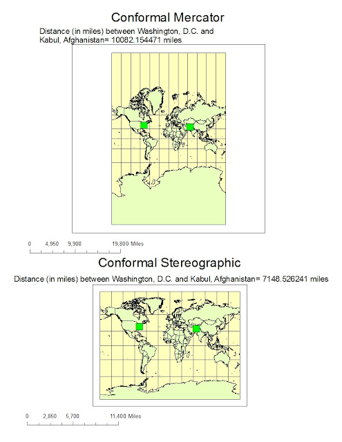
           Map projections are significant to portray the surface of the earth or a portion of the earth on a flat surface. There are three main types of projections, which are conformal, equal area, and equidistant. They are based on distortions of conformality, distance, direction, scale, and area. Distortions of these properties are minimized by specific map projections at the expense of making errors in other aspects. For instance, in conformal map projection, the scale of a map at any point on the map is the same in any direction. Meridians and parallels intersect at right angles. Shapes as perfect circles are preserved locally on conformal maps. In this assignment, I quote Mercator as an example of conformal maps. The Mercator projection has straight meridians and parallels, which intersect at right angles. Scale is true at the equator or at two standard parallels equidistant from the equator. The projection is often utilized for marine navigation because all straight lines on the map are lines of constant azimuth. Another example for conformal map projection is Stereographic. Stereographic projections are applied for navigation in Polar Regions. Directions are true from the center point.
             As for equal area map projection, a map portrays areas over the entire map so that all mapped areas have the same proportional relationship to the areas on the Earth that they represent. An example is Sinusoidal equal-area maps. They have straight parallels at right angles to a central meridian. Scale is true only on the central meridian and the parallels. The maps are often employed in countries with a larger north-south than east-west extent. Last but not least, equidistant maps are important for portraying distances from the center of the projection to other places on the map. For example, equidistant conic and equidistant cylindrical maps distort direction, area, and shape away from standard parallels. They are used for portrayals of areas near to the equator.
              One of the advantages and potentials of using map projections is that they are easy to be used. It is because the only way to get an exact duplication of the Earth is to project the globe from a three dimensional planet to a two dimensional plane. The two dimensional representation is easier to be carried around for the study of geographical information. Another potential of map projections is for commuting and traveling. We can easily collect crucial data to strengthen our understanding of the relationships between places on the Earth. For instance, equidistant conic projections preserve distances on the earth so they are useful for showing directions when commuting. This preservation assists travelers to estimate the resources they will need, such as traveling distance, gas, and time, to efficiently commute between two locations. Consequently, we can make good use of different map projections according to our specific researching purposes. For example, the equal-area Mollweide projections may help researchers to map the areas of urbanization because vicinity is preserved.
             However, map projections have pitfalls and perils. The basic problem inherent in any type of map projection is that it will result in some distortion of the ‘ground truth’ of the area being mapped. As we can see in the figure above, large objects in the projection are distorted in the Mercator projection, while Antarctica becomes a huge land mass covering almost half the map.There are four basic characteristics of a map that are distorted to some degree, depending on the projection used. These characteristics involve distance, direction, shape, and area. The only place on a map where there is no distortion is along the trace of the line that marks the intersection of our ‘paper’ with the surface of the earth. Any place on the map that does not lie along this line will suffer some distortion. Therefore, different map projections provide inconsistent information about distance, direction, shape, and area. Essentially, by looking at the Mercator projection, I measured that the distance between Washington D.C. and Kabul is around 10,000 miles while it is only around 5000 miles in the equidistant cylindrical projection.  The equidistant cylindrical projection is more reliable because it preserves distances between points on the earth, whereas the conformal Mercator does not preserve distances. Users may get confused if they do not understand the preserved properties of different map projections. Fortunately, depending on the type of projection used, at least one of the four characteristics can generally be preserved. As a result, we should remember to make sure that we are using the right map projection to collect geographical information. If we choose the wrong one, inaccurate data will be found, which will adversely affect our interpretation and analysis of the data. Therefore, we should identify the correct maps and understand their potentials and pitfalls before using them.


Tuesday, November 2, 2010

Lab 4 Introducing ArcMap

            
This was my first time to use ArcGIS, so I carefully followed every instruction from ArcGIS tutorial to prevent mistakes. In the beginning, I felt unfamiliar to use Arc catalogue to move files and export them. However, I had been able to copy the lab files correctly into my folder using Arc Catalogue. After a long process of trials and errors, I considered that the funniest part of this whole assignment was to see my final product, which increased my sense of satisfaction.  I was delighted about learning how to add and edit map elements, display and visualize attributes, manipulate fundamental spatial statistics and manual editing, and layout the map. These skills and knowledge are definitely valuable for my future to edit geographical data.
Through doing this assignment, I understand that ArcGIS consists of an optimized map service that allows us to produce high-performance dynamic maps. I noticed that map quality is good, and storage is efficient. Moreover, the software lets users easily share geographic content, such as maps, data, and layers. ArcMap data, such as a thumbnail, the extent, and spatial reference, is an easy-to-share package. Layer packages can be shared via e-mail or DVD or placed on network drives.
Geographic Information Systems (GIS) benefit organizations of almost every industry. There is a growing interest in and awareness of the economic and strategic value of GIS, in part because of more standards-based technology and greater awareness of the benefits demonstrated by GIS users. First, GIS save costs because of greater efficiency. For instance, they encourage labor savings from automating or improving a workflow.  An example of labor saving by GIS is Sears, which implemented GIS in its logistics operations and has seen dramatic improvements.  Sears considerably reduced the time it takes for dispatchers to create routes for their home delivery trucks by about 75%. Another potential of GIS is better decision making about location. Common examples are environmental conservation, natural resource extraction, zoning, planning, real estate site selection, route/corridor selection, etc. Next, GIS-based maps help understanding situations and story-telling. It improves communication between different teams, departments, disciplines, professional fields, organizations, and the public. Furthermore, the system provides better geographic information recordkeeping with full transaction support and reporting tools. Furthermore, GIS have become essential to understand what is going on in government and many large corporations, including briefings about various geographic patterns and relationships of land use, crime, the environment, and defense/security situations. Finally, GIS implemented as enterprise information systems.  The systems are transforming the way that organizations manage their assets, serve their customers, make decisions, and communicate. Examples in the private sector include forestry and oil companies, and most retail businesses. Their assets and resources are now being maintained as an enterprise information system to support day-to-day work management tasks and provide a broader context for assets and resource management.
On the other hand, geographic information systems have injustices in assessing environmental health and equity. They also expose disproportion of certain populations to environmental hazards. Unresolved issues in mapping environmental equity and health are due to a lack of comprehensive hazards databases, insufficient realistic methodologies for determining the geographic extent of exposure and the characteristics of the affected populations, and the paucity of health assessment data. Since a spatial frontier may be overlaid on areas where peripheries are not well defined, some animals may not be distinguished in these margins. Therefore, GIS map may not fully represent the invasion of an ecosystem successfully. Another pitfall of GIS is that terrorists could possibly use GIS to detect high risk areas, commit crimes, and harm specific locations. Therefore, GIS has both good and bad sides. One should apply the systems carefully.

Friday, October 15, 2010

Lab 3: Create my own map =) Fun Eastern Washington Road Trip


View Fun Eastern Washington Road Trip in a larger map


      As for the potential of neogeography, online interactive maps assists to extend information rapidly and straightforwardly. User-created maps are well-organized methods of assigning important information to people who dislike a paper maps. Moreover, neogeography lets us share our individual analysis of the same geographical area. The individualized maps also add a social understanding of the vicinity. However, this extensive data source holds some risks according to how the data is explained and applied. 
      Because these types of maps can be edited with no trouble and they look proficient, they may endow with misinformation. People would be misinformed into trusting the wrong data. Furthermore, the fact that the advanced programming does all of the thinking for the users may lead to a dilapidation in users’ investigative skills. Another drawback of neogeography is a threat to privacy and security. Neogeography allows for an exchange of personal information among the crowd, such as sexual orientation and political alliance. This implies that people can be targeted for crimes. Last but not least, if we over-rely on online maps, we may get lost if the area does not have internet access on the way of our trips. Therefore, paper maps are still worthwhile and reliable to be used in addition to google or yahoo maps. 


Saturday, October 9, 2010

Lab 2 Interesting map reading


1.      What is the name of the quadrangle?
Beverly Hills quadrangle.

2.      What are the names of the adjacent quadrangles?
1. Canoga Park
2. Van Nuys
3. Burbank
4. Topanga
5. Hollywood
7. Venice
8. Inglewood

3.      When was the quadrangle first created?
Year of 1966


4.      What datum was used to create your map?
2 horizontal datum: North American Datum of 1927 and 1983
1 vertical datum: National Geodetic vertical datum of 1929


5. What is the scale of the map?
 R.F. = 1:24000

6. At the above scale, answer the following:
a) 5 centimeters on the map is equivalent to how many meters on the ground?
1/24000 = map/ground
 1/24000 = 5cm/ground
Ground= 5*24000cm
             = 120000cm
             = 1200m  

b) 5 inches on the map is equivalent to how many miles on the ground?
1/24000= 5inches/ ground
Ground = 5*24000 inches
             = 120000inches
             = 1.8939 miles

c) one mile on the ground is equivalent to how many inches on the map?
1/24000= map/ 1mile
Map=1/ 24000 miles
       = (63360inches /1mile) * (1mile/ 24000)
       = 63360/ 24000 inches
       = 2.64 inches


d) three kilometers on the ground is equivalent to how many centimeters on the map?
1/24000= map/ 3km
Map= 3/24000 km
        = (100000cm/1km)*(3km/24000)
        = 12.5 cm

7. What is the contour interval on your map?
 20 feet

8. What are the approximate geographic coordinates in both degrees/minutes/seconds and decimal degrees of:
a) the Public Affairs Building;
Longitude (P.A.)= 118.30’-x
Distance( left- right)/Distance(left-P.A.)= 7.5’/x = 70cm/33cm
x= 3.54’
118.30’- 3.54’= 118.26.46’  
0.46’=60”*0.46=27.6”
Therefore, the longitude is 118. 26’28”

Decimal degree:
 26minutes*60seconds= 1560 sec
1560 + 28= 1588 sec
1588/3600 sec=.441 degree
Therefore, the longitude is 118.441 degree

Latitude (P.A.)= 34.07’30”-x
Distance( up- down)/Distance( up-P.A.)= 7.5’/x = 28.7cm/ 11.7cm
X= 2.45’
34.07’30”- 2.45’= 34.4.55’30”  
0.55’=60”*0.55=33”
34.04’63”=34.05’03”
Therefore, the latitude is 34.05’03”

Decimal degree:
5 minutes*60seconds= 300 sec
300 + 3= 303 sec
303/3600 sec=.0841 degree
Therefore, the latitude is 34.084 degree

b) the tip of Santa Monica pier;
Longitude= 118.29’52” (118.498 degree)
Latitude= 34.00’31” (34.009 degree)

c) the Upper Franklin Canyon Reservoir;
Longitude= 118.24’39”  (118.411 degree)
Latitude= 34.07’12” (34.12 degree)

9. What is the approximate elevation in both feet and meters of:
a) Greystone Mansion (in Greystone Park);
600feet- 20feet = 580 feet
580 feet = 176. 784 meters

b) Woodlawn Cemetery;
140 feet
42.672 meters

c) Crestwood Hills Park;
Around 630 feet
192.024 meters

10. What is the UTM zone of the map?
Zone 11.

11. What are the UTM coordinates for the lower left corner of your map?
361.5 Easting and 3763 Northing

12. How many square meters are contained within each cell (square) of the UTM gridlines?
1000*1000m= 1000000 square meters

13. Obtain elevation measurements, from west to east along the UTM northing 3771000, where the eastings of the UTM grid intersect the northing. Create an elevation profile using these measurements in Excel (hint: create a line chart). Figure out how to label the elevation values to the two measurements on campus. Insert your elevation profile as a graphic in your blog.

14. What is the magnetic declination of the map?
14 degree

15. In which direction does water flow in the intermittent stream between the 405 freeway and Stone Canyon Reservoir?
Water flows from north to south.

16. Crop out (i.e., cut and paste) UCLA from the map and include it as a graphic on your blog.